

File:Map of territorial growth 1775-es.svg

Captions
Captions
Summary
[edit]| Description |
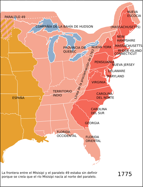
Català: Les Tretze Colònies americanes, la província de Quebec i el Territori Indi segons el decret reial de 1763.
Español: Las Trece Colonias Británicas en Norteamérica, la provincia de Quebec y el Territorio Indio según el decreto real de 1763. Deutsch: Östliches Nordamerika im Jahre 1775 mit den vom Königreich Großbritannien kontrollierten Provinz Quebec und den dreizehn Kolonien an der Küste sowie dem von diesen durch die Proklamationslinie von 1763 abgeschiedene Indian Reserve (siehe auch: Britische Kolonisierung Amerikas).
English: Eastern North America in 1775: The British Province of Quebec, the British thirteen colonies on the Atlantic coast and the Indian Reserve (as of the Royal Proclamation of 1763).
Italiano: Nel 1775, l'Inghilterra aveva il dominio sulle zone indicate in rosso e rosa sulla mappa e la Spagna su quelle arancione. La zona rossa è quella relativa alle 13 colonie aperte agli insediamenti dopo la proclamazione del 1763. |
| Date | |
| Source |
This file was derived from: Map of territorial growth 1775.svg:  |
| Author |
|
| Other versions |
File:Map of territorial growth 1775-es.svg contains 2 translations.
Other related versions: []
|




|
This SVG file contains embedded text that can be translated into your language, using any capable SVG editor, text editor or the SVG Translate tool. For more information see: About translating SVG files. |


|
This file is translated using SVG <switch> elements. All translations are stored in the same file! Learn more.
For most Wikipedia projects, you can embed the file normally (without a To translate the text into your language, you can use the SVG Translate tool. Alternatively, you can download the file to your computer, add your translations using whatever software you're familiar with, and re-upload it with the same name. You will find help in Graphics Lab if you're not sure how to do this. |
Licensing
[edit]


- You are free:
- to share – to copy, distribute and transmit the work
- to remix – to adapt the work
- Under the following conditions:
- attribution – You must give appropriate credit, provide a link to the license, and indicate if changes were made. You may do so in any reasonable manner, but not in any way that suggests the licensor endorses you or your use.
- share alike – If you remix, transform, or build upon the material, you must distribute your contributions under the same or compatible license as the original.
File history
Click on a date/time to view the file as it appeared at that time.
| Date/Time | Thumbnail | Dimensions | User | Comment | |
|---|---|---|---|---|---|
| current | 22:47, 23 December 2024 | | 506 × 662 (241 KB) | Manlleus (talk | contribs) | File uploaded using svgtranslate tool (https://svgtranslate.toolforge.org/). Added translation for ca. |
| 05:48, 3 March 2023 |  | 506 × 662 (229 KB) | Johnn Francis (talk | contribs) | Reverted to version as of 16:20, 18 October 2012 (UTC) Este mapa describe la situación en el año 1775. Florida fue adquirida por Gran Bretaña en 1763 de España (quien volvería a adquirirla en 1783). Por lo tanto, Florida (tanto el oeste como el este) era británica en el momento en que se establece este mapa. | |
| 16:36, 19 December 2022 |  | 506 × 662 (223 KB) | PatriaDeTodos (talk | contribs) | Florida fue española entre 1513 y 1821 | |
| 16:20, 18 October 2012 |  | 506 × 662 (229 KB) | Rowanwindwhistler (talk | contribs) | User created page with UploadWizard |
You cannot overwrite this file.
File usage on Commons
The following 11 pages use this file:
- User:Magog the Ogre/Maps of conflicts/2022 December
- User:Magog the Ogre/Maps of conflicts/2023 March
- User:Magog the Ogre/Maps of conflicts/2024 December
- User:Magog the Ogre/Multilingual legend/2022 December 11-20
- User:Magog the Ogre/Multilingual legend/2023 March 1-10
- User:Magog the Ogre/Multilingual legend/2024 December 22-26
- File:Map Thirteen Colonies 1775.svg
- File:Map of territorial growth 1775-es.svg
- File:Map of territorial growth 1775.jpg
- File:Map of territorial growth 1775.svg
- Template:Other versions/Map of territorial growth 1775
File usage on other wikis
The following other wikis use this file:
- Usage on ca.wikipedia.org
- Guerra de la Independència dels Estats Units
- Tretze Colònies
- Batalles de Lexington i Concord
- Batalla de Pensacola
- Batalla de Fort Charlotte
- Batalla de Mobile
- Batalla de Yorktown (1781)
- Batalla de Saratoga
- Batalla de Bunker Hill
- Batalla de Baton Rouge (1779)
- Setge de Charleston
- Batalla de Brandywine
- Batalla de Germantown
- Batalla de Kings Mountain
- Batalla de Monmouth
- Batalla de Princeton
- Batalla de Trenton
- Batalla de Chesapeake
- Plantilla:Location map 13 Colònies
- Captura de Fort Bute
- Assimilació cultural dels amerindis dels Estats Units
- Proclamació reial de 1763
- Indian Intercourse Act
- Teatre nord de la Guerra de la Revolució Americana després de Saratoga
- Teatre oest de la Guerra de la Revolució Americana
- Teatre sud de la Guerra de la Revolució Americana
- Campanya de Yorktown
- Operacions navals de la Guerra de la Revolució Americana
- Nova Escòcia a la Revolució Americana
- Campanya de la Costa del Golf
- Invasió del Quebec (1775)
- Campanya de Filadèlfia
- Campanya de Nova York i Nova Jersey
- Campanya de Saratoga
- Província de Geòrgia
- Mòdul:Location map/data/13 Colònies
- Mòdul:Location map/data/13 Colònies/ús
- Sistema de Demarcació del Territori Públic
- Usage on en.wikipedia.org
- Usage on es.wikipedia.org
- Usage on ia.wikipedia.org
- Usage on www.wikidata.org
